Other Agritech Resources

Drones in Agriculture

Ensuring periodic and consistent field and crop health monitoring to enable timely interventions and better yield with agriculture drone services.
DRONES IN AGRITECH

Crop Health Assessment

Drones, also called Unmanned Aerial Devices (UAVs), can help spot bacterial and fungal infections on trees in a field. The UAV uses remote sensing techniques that help in monitoring crop health at every stage since they are first sown. The periodic drone assessments use vegetative indices to display the results via guided NDVI images.
DRONES IN AGRITECH

Crop Surveillance

Drones enable us to stay updated on the area-wise crop health and status in a very large field. These fields are inspected using drones that collect data that reveal real-time and accurate information about the crops. This process is also known as agriculture mapping, it also helps in enhancing agriculture insurance tools.
DRONES IN AGRITECH

Precision Farming Solutions

Agrotech India also offers localised studies at farm field levels. The data analysis done helps in forecasting the parcel level yield, estimating any losses at the plot level, detecting frauds, and validating farmer ownership.
DRONES IN AGRITECH

Controlling Weed, Insects, Pests, And Diseases

Drones can help in depicting soil information as well as inform the stakeholders about which field areas are inflicted by weeds, diseases, and pests. Based on this information, appropriate measures can be taken by the farmers to achieve better field and crop health.
DRONES IN AGRITECH

Crop Monitoring And Acreage Estimation

Over time, crop monitoring has become a big problem for all agriculture stakeholders. Infrequent and inefficient crop monitoring can lead to crop losses and increased maintenance costs. To reduce this risk, periodic drone-assisted crop monitoring and acreage estimation are done by Agrotech India. These investigations happen throughout the season and are as detailed as they can be. It is ensured that these are done on a fortnightly basis.
All drone crop surveys use remote sensing technology to field data and process them into meaningful information that will help in improving field health.

methodology

Drones in Agritech

Upon receiving details on the Area of Interest (AOI) from the client, the field and its surrounding areas are assessed to see if they are fit for using drones. Everything is planned at this stage; from checking for no-fly-zones to evaluating the time required for data processing.
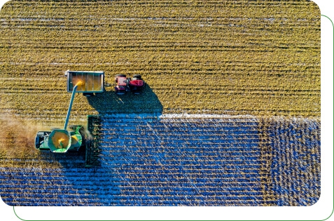
Once the planning is done, drones are flown over the AOI. These drones fly using software that guides their trajectory. This software allows us to make the flight plan and feed in parameters like speed and altitude as desired.
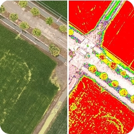
During the flight, drones capture images that have a 70% overlap and sidelap. In the processing stage, the images are processed through image mosaicking software to attain a seamless map of the AOI. This map is then used for further analysis.
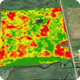
Data analysis of the information picked up by the drone is presented in the form of a report to our client. This report helps in understanding the current crop health and enables farmers to react on time to improve the growth conditions. It also improves crop management and increases the chances of better yield.

Drones in Agritech

The Versatility of Drones

Remote sensing technology is essential for all drone-assisted crop monitoring.
This technology can be used to process raw data in multiple ways based on the
core requirement of each project. Discover the versatility of the tech.

Drones in Agritech

Why are Drones Superior
To Other Mediums?

Optical-Electronic Sensors

Unlike remote sensing from satellites, the optical-electronic sensors of UAVs give ultra-high resolution in spectral scans. These also allow for geotagging and are accurate up to 5cm.

Crop Signature Collection and Field Studies

On-site and mobile sensors use UAV technology to get factual information on field properties. Lab analysis of agriculture specimens is done to find out the soil humidity, temperature, and atmospheric pressure using this technology.